Mystery author Beth Groundwater writes the Claire Hanover gift basket designer series (A REAL BASKET CASE, 2007 Best First Novel Agatha Award finalist, TO HELL IN A HANDBASKET, 2009, and A BASKET OF TROUBLE, 2013) and the RM Outdoor Adventures series starring river ranger Mandy Tanner (DEADLY CURRENTS, 2011, an Amazon bestseller, WICKED EDDIES, 2012, finalist for the Rocky Award, and FATAL DESCENT, 2013). Beth lives in Colorado, enjoys its outdoor activities, and loves talking to book clubs.
Showing posts with label whitewater rafting. Show all posts
Tuesday, June 11, 2013
9 Tips for a Great Whitewater Rafting Trip
As part of my promotion week activities to celebrate the release of Fatal Descent, the third book in my RM Outdoor Adventures mystery series starring whitewater river ranger/rafting guide Mandy Tanner, I'm going to whet your appetite for whitewater rafting.
HERE is a link to an excellent article from The Breck Connection, a blog from the Breckenridge Resort Chamber with answers to questions often posed at The Breckenridge Welcome Center. I know the editor of the blog, Kimberly Nicoletti, and she's an excellent writer. The author of this article is Mark Hammer. Owner of The Adventure Company, he was a rafting guide for 16 years before purchasing the business in 2003, giving him 26 years of experience on the river.
Titled "9 Tips for a Great Colorado Whitewater Rafting Trip," the article gives you factors to consider when planning a trip, so it's a success for all involved. I removed "Colorado" from the title today's blog article, because the tips are general enough to apply to planning a whitewater rafting trip just about anywhere.
Advice that I give people who ask me about whitewater rafting, and that I would add to Mark's tips is: 1) you should be at least a beginner swimmer, who won't panic if pitched into the water and who can make some basic swimming strokes toward the raft or shore, and 2) you should be honest about your medical issues on the rafting company's registration form and take all essential medications on the raft with you. I still remember the story told to me by a rafting guide, with a haunted look in his eyes, of his first client death on the river. The older man with asthma and other health issues lied on his form and didn't bring his inhaler or medications on the trip, because he was afraid he wouldn't be allowed to go. After he was pitched into the cold river and pulled out by the guide, he could not get his breath and died in the guide's arms while they waited for the county's emergency medical crew to arrive.
I don't want to scare anyone from going whitewater rafting, but it is an adventurous outdoor activity with uncontrollable elements, and YOU are a vital factor in making sure you stay safe.
Saturday, June 08, 2013
Release Day for FATAL DESCENT!!
Today is the official release day for FATAL DESCENT, the third book in my RM Outdoor Adventures series starring whitewater river ranger/rafting guide Mandy Tanner. Follow the link for the book blurb, reviews, an excerpt, discussion questions, and "buy me" links. I hope you'll celebrate the release with me by lifting a glass of your favorite beverage and wishing me luck. Buying a copy for yourself wouldn't hurt either! ;-)
Friday, May 03, 2013
The Ark Sharks
Since I write a mystery series featuring a whitewater river ranger and rafting guide, the RM Outdoor Adventures series, I am interested in all things related to whitewater rafting and competitions in the sport. Recently my local newspaper, the Summit Daily News, ran a feature article on the Ark Sharks, a local world-class competitive whitewater rafting team based right here in my hometown of Breckenridge, Colorado. All the members of the team work as river guides in Colorado, with most of their time spent working the Arkansas River, thus the name Ark Sharks. When they aren't working, they like to play on the river with kayaks, canoes, or any conveyance that is river-related. Here's their Facebook page, an interview with them, and a video of them in action.
Monday, July 02, 2012
Saving Guatemala's Wild Rivers
Last Friday, my husband and I saw a beautiful, moving, and adventuresome film at the Colorado Mountain College auditorium in Breckenridge. Titled Rios Guatemala, it chronicles an expedition down some beautiful and exciting whitewater rivers in Guatemala. It also shows the brave diplomacy that had to come into play when angry Mayan villagers detained paddlers they mistook for hydroelectric engineers. The expedition had to convince the Mayans that they had the same goals--to preserve and protect the rivers.
The film was made to bring attention to the danger threatening these Guatemalan rivers, due to proposed dam and mine development, and to the need for developing a sustaining ecotourism industry in the area. Ecotourism would offer an alternative to exploitation of these wild and pristine rivers and provide a source of income to the indigenous Mayan people. The film is being shown in the United States to attract attention and funding to a brand new foundation, the Rios Guatemala Foundation.
After viewing the film, I was ready to go to Guatemala! What a beautiful country, and what an amazing trip it would be to paddle down those roaring rivers. To see previews of the film on YouTube, go HERE and HERE.
To find out more about the Rios Guatemala Foundation and its mission to provide for the enjoyment, preservation and restoration of wild rivers in Guatemala, go HERE. You can see and hear the director, Guatamalan native Max Baldetty, talk about their vision at the website. You can read a mouth-watering description of their planned "Highlands to the Sea" fundraising expeditions on the Rios Lanquin and Cahabon, named by Paddler Magazine as one of the twelve best jungle river trips in the world. And you can gather a group of whitewater paddling friends and contact the foundation to schedule your own trip of a lifetime. You can feel good about it, too, because twenty percent of the trip sales go directly to the RIOS Guatemala Foundation and the preservation and restoration of river ecosystems in Guatemala.
The film was made to bring attention to the danger threatening these Guatemalan rivers, due to proposed dam and mine development, and to the need for developing a sustaining ecotourism industry in the area. Ecotourism would offer an alternative to exploitation of these wild and pristine rivers and provide a source of income to the indigenous Mayan people. The film is being shown in the United States to attract attention and funding to a brand new foundation, the Rios Guatemala Foundation.
After viewing the film, I was ready to go to Guatemala! What a beautiful country, and what an amazing trip it would be to paddle down those roaring rivers. To see previews of the film on YouTube, go HERE and HERE.
To find out more about the Rios Guatemala Foundation and its mission to provide for the enjoyment, preservation and restoration of wild rivers in Guatemala, go HERE. You can see and hear the director, Guatamalan native Max Baldetty, talk about their vision at the website. You can read a mouth-watering description of their planned "Highlands to the Sea" fundraising expeditions on the Rios Lanquin and Cahabon, named by Paddler Magazine as one of the twelve best jungle river trips in the world. And you can gather a group of whitewater paddling friends and contact the foundation to schedule your own trip of a lifetime. You can feel good about it, too, because twenty percent of the trip sales go directly to the RIOS Guatemala Foundation and the preservation and restoration of river ecosystems in Guatemala.
Friday, March 09, 2012
Water Sports Blogs and Websites I Recommend

Given that my RM Outdoor Adventures mystery series has a whitewater river ranger as its sleuth, you would expect me to have my finger on the pulse of the whitewater sports community, and you would be right. If reading Deadly Currents has piqued your interest in this activity and you want to learn more, here's some recommended blogs and websites:
American Canoe Association blog
American Rivers blog, a river conservation organization that I support
River Ranger blog (particularly if you're inspired to become a river ranger and are looking for job postings)
Waterblogged, the blog for O.A.R.S.
Rafting.AllAboutRivers.com for a list of outfitters serving each state with whitewater rivers
Whitewater Rafting for similar information about outfitters throughout the US
Rafting Colorado website for information about Colorado outfitters
About.com's Whitewater festival calendar
FIBArk whitewater rafting festival website
US National Whitewater Center website, where our Olympic whitewater athletes train
Monday, November 14, 2011
An Amazing Gift from a Fellow Writer
Andrea Gonzales is a fellow Colorado crime fiction writer and member of Sisters in Crime and the Rocky Mountain Chapter of Mystery Writers of America (RMMWA). Recently I guested on her blog, answering a number of interview questions. As a thank-you for my appearance, and some other assistance I gave her, Andrea made a miniature tableau (see below) featuring my books and the whitewater rafting theme of my RM Outdoor Adventures mystery series, complete with lifejacket (PFD), raft, and paddles. It absolutely blew me away!

Andrea is an illustrator as well as a writer, and this tableau shows her artistic talent. I've already shown it off to my critique group and at the RMMWA meeting. I'm also placing it on my signing table during all of my Colorado-based events this week for people to admire (see the Appearances page of my website). I hope you'll visit Andrea's website to learn more about this talented lady. :)

Andrea is an illustrator as well as a writer, and this tableau shows her artistic talent. I've already shown it off to my critique group and at the RMMWA meeting. I'm also placing it on my signing table during all of my Colorado-based events this week for people to admire (see the Appearances page of my website). I hope you'll visit Andrea's website to learn more about this talented lady. :)
Labels:
Andrea Gonzales,
miniature,
whitewater rafting
Saturday, October 08, 2011
Book Research Trip to Moab, Utah: Part Three
On the last two days, I posted photos from the first two thirds of my book research trip to Moab, Utah. I'll finish up today with photos from the last day of my 3-day, 100-mile trip on the Colorado River through Meander Canyon and Cataract Canyon and on into Lake Powell. The last day of the river trip started with the three biggest rapids of the whole journey, Big Drop 1, 2, and 3. The photo below shows our boatman Dave powering upstream while scouting a rapid downstream over his shoulder to find the best path through it.

In the photos below, you'll see how wet we got (from head to toe--see the water pouring off the rafter in the first photo) and how carefully we're clutching on to the boat ropes and metal handholds to stay INSIDE the J-rig. We did not want to swim those rapids!


However, in a gentler class II rapid downstream, the guides said folks could try swimming a rapid, and my adventuresome hubby jumped in (see below).

After running the last eight rapids, we reached the placid waters of Lake Powell (first photo below) that had backed up into Cataract Canyon and flooded the remaining rapids. We beached at Dark Canyon to eat lunch and hike through a muddy stream bed back to a short waterfall (second and third photos below). Then it was my turn for a swim in Lake Powell (last photo below).


A great feature of the trip was a scenic ride in a six-seater airplane from Hite Marina on Lake Powell back to the Moab airport. We were able to see many of the places we'd been from the air, including Lake Powell (first photo), the Big Drop rapids (second photo), the confluence of the Green and Colorado Rivers (third photo) and the area where we hiked over the relatively lower spot in the canyon wall from one side of "The Loop" to the other. The last photo below shows the plane.


That night we took hot showers, soaked in the motel's hot tub, changed into clean clothes, ate a delicious Thai dinner in town, and fell into soft, comfy beds. Ah! The next day was a very full one. First we drove into the Island in the Sky portion of Canyonlands National Park and visited all of the overlooks and the famous Mesa Arch (photo below).

Then we drove the dirt switchback Shafer Trail (first photo below) down to a remote overlook (second photo below). There were several EEK moments on that trail!


After that we visited Dead Horse Point State Park to look down on a river section that we had rafted days before. Then we rushed over to Arches National Park so my hubby could capture a couple of more iconic photos before the sun set. Balanced Rock is in the first photo and Delicate Arch is in the second. The last one shows the mass of photographers from all over the world who at the ready to take that sought-after sunset shot of Delicate Arch.


We made friends with some of the photographers who had flashlights (we'd rushed up the 1.5 mile trail without ours) and hiked back in the dark with them lighting the way. After a delicious Mexican dinner at 9 PM, we fell into bed. A jam-packed week in Moab, and we still want to go back!

In the photos below, you'll see how wet we got (from head to toe--see the water pouring off the rafter in the first photo) and how carefully we're clutching on to the boat ropes and metal handholds to stay INSIDE the J-rig. We did not want to swim those rapids!


However, in a gentler class II rapid downstream, the guides said folks could try swimming a rapid, and my adventuresome hubby jumped in (see below).

After running the last eight rapids, we reached the placid waters of Lake Powell (first photo below) that had backed up into Cataract Canyon and flooded the remaining rapids. We beached at Dark Canyon to eat lunch and hike through a muddy stream bed back to a short waterfall (second and third photos below). Then it was my turn for a swim in Lake Powell (last photo below).


A great feature of the trip was a scenic ride in a six-seater airplane from Hite Marina on Lake Powell back to the Moab airport. We were able to see many of the places we'd been from the air, including Lake Powell (first photo), the Big Drop rapids (second photo), the confluence of the Green and Colorado Rivers (third photo) and the area where we hiked over the relatively lower spot in the canyon wall from one side of "The Loop" to the other. The last photo below shows the plane.


That night we took hot showers, soaked in the motel's hot tub, changed into clean clothes, ate a delicious Thai dinner in town, and fell into soft, comfy beds. Ah! The next day was a very full one. First we drove into the Island in the Sky portion of Canyonlands National Park and visited all of the overlooks and the famous Mesa Arch (photo below).

Then we drove the dirt switchback Shafer Trail (first photo below) down to a remote overlook (second photo below). There were several EEK moments on that trail!


After that we visited Dead Horse Point State Park to look down on a river section that we had rafted days before. Then we rushed over to Arches National Park so my hubby could capture a couple of more iconic photos before the sun set. Balanced Rock is in the first photo and Delicate Arch is in the second. The last one shows the mass of photographers from all over the world who at the ready to take that sought-after sunset shot of Delicate Arch.


We made friends with some of the photographers who had flashlights (we'd rushed up the 1.5 mile trail without ours) and hiked back in the dark with them lighting the way. After a delicious Mexican dinner at 9 PM, we fell into bed. A jam-packed week in Moab, and we still want to go back!
Labels:
book research,
Cataract Canyon,
Colorado River,
Moab,
Utah,
whitewater rafting
Friday, October 07, 2011
Book Research Trip to Moab, Utah: Part Two
As I posted yesterday, my hubby and I recently traveled to Moab, Utah so I could conduct research for the third book in my Rocky Mountain Outdoor Adventures mystery series starring whitewater river ranger Mandy Tanner. In that book, Mandy and her lover and outfitter business partner, Rob Juarez, will lead a multi-day rafting trip down 100 miles of the Colorado River in Utah, through the stillwaters of Meander Canyon and the class III and IV whitewater rapids of Cataract Canyon, one of the most remote whitewater rafting canyons in the United States. So, of course, I had to take the same trip!
Here are some photos from that amazing journey. First are some petroglyphs, rock art carved by ancestral Puebloans into the desert patina of the cliffside that could be seen along the road to our put-in at the Potash Boat Ramp west of Moab on the Colorado River.

The photo below shows boatman Dave and me loading the J-rig, a configuration of two large pontoons with a metal platform slung between them that is powered by an outboard motor in the back. Beside the J-rig is a high-speed motorized launch from Tag-A-Long (the highly recommended outfitter we used for our trip) that drops and picks up canoes and paddlers from various places in Meander Canyon. The next photo shows an early stop in our journey at a petrified forest site below Dead Horse Point, with river guide Justin peering at one large, long log.


The photo below is of a party flotilla we encountered in Meander Canyon (heavy drinking involved, I'm sure!), and the one after that is of a ancient granary across the river from Lathrop Canyon. The third photo shows the "bathtub ring," a white layer of rock that is very striking in parts of the canyon.


The next two photos are from our hike over a short intersection between two loops in the Colorado River, while Dave and Justin took the boat four miles around the meander to meet us on the other side. The first photo shows me climbing up on one side and second shows the two of us overlooking the other side and the beach where we camped that evening. The third photo shows the kitchen set up at that camp and the last is of sunset bathing the rocks with beautiful orange light. A wonderful first day!


On the morning of the second day of our 3-day trip, we motored down to the confluence with the Green River, which swelled the volume of the Colorado River to about 12,000 cfs (cubic feet per second). For the Cataract Canyon section, this was a fairly low volume of water, which can rise to around 60,000 cfs in spring flood season. Below the confluence, we pulled in to register at the danger sign for our campsite that evening (see below).

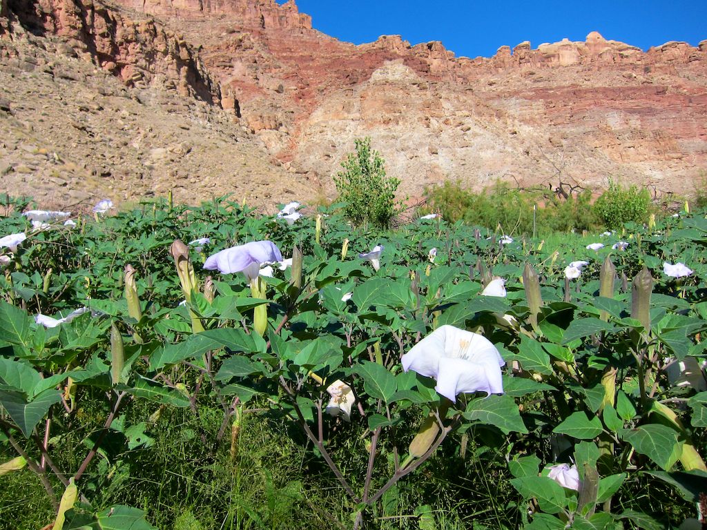
The next stop was at a large flat beach area called Spanish Bottom, where we hiked to the Doll House formation at the top of the canyon rim after going through a field of moonflowers (see below). These plants are also called sacred datura or jimson weed and were used by the native Americans to induce hallucinations during ceremonies. The second photo shows part of the Doll House formation at the top and the third shows the view down to the river from there.


Now, on to the rapids! Cataract Canyon contains 28 major class III or class IV rapids within its 30 miles. We didn't get a whole lot of photos of the rapids because we were supposed to hold on with BOTH hands when we went through them. I told my dear hubby I'd rather he'd hold on than snap photos for me, so the ones he took were just before or just after running a rapid.

We pulled out for the night after rapid 20 and just before the next three rapids, which are called Big Drop 1, 2, and 3. We walked down the river bank to see what we had to look forward to the next day. Below is a photo of Big Drop 1, and here's a link to a video of it, with myself and one of my fellow rafters added for size: http://www.youtube.com/watch?v=pTqh6OgR9rA

The last photo is of our campsite on Big Drop Beach the second night. I plan to post photos tomorrow from the last day of the rafting trip and of the next day we spent in Moab at Canyonlands National Park.
Here are some photos from that amazing journey. First are some petroglyphs, rock art carved by ancestral Puebloans into the desert patina of the cliffside that could be seen along the road to our put-in at the Potash Boat Ramp west of Moab on the Colorado River.

The photo below shows boatman Dave and me loading the J-rig, a configuration of two large pontoons with a metal platform slung between them that is powered by an outboard motor in the back. Beside the J-rig is a high-speed motorized launch from Tag-A-Long (the highly recommended outfitter we used for our trip) that drops and picks up canoes and paddlers from various places in Meander Canyon. The next photo shows an early stop in our journey at a petrified forest site below Dead Horse Point, with river guide Justin peering at one large, long log.


The photo below is of a party flotilla we encountered in Meander Canyon (heavy drinking involved, I'm sure!), and the one after that is of a ancient granary across the river from Lathrop Canyon. The third photo shows the "bathtub ring," a white layer of rock that is very striking in parts of the canyon.


The next two photos are from our hike over a short intersection between two loops in the Colorado River, while Dave and Justin took the boat four miles around the meander to meet us on the other side. The first photo shows me climbing up on one side and second shows the two of us overlooking the other side and the beach where we camped that evening. The third photo shows the kitchen set up at that camp and the last is of sunset bathing the rocks with beautiful orange light. A wonderful first day!


On the morning of the second day of our 3-day trip, we motored down to the confluence with the Green River, which swelled the volume of the Colorado River to about 12,000 cfs (cubic feet per second). For the Cataract Canyon section, this was a fairly low volume of water, which can rise to around 60,000 cfs in spring flood season. Below the confluence, we pulled in to register at the danger sign for our campsite that evening (see below).
The next stop was at a large flat beach area called Spanish Bottom, where we hiked to the Doll House formation at the top of the canyon rim after going through a field of moonflowers (see below). These plants are also called sacred datura or jimson weed and were used by the native Americans to induce hallucinations during ceremonies. The second photo shows part of the Doll House formation at the top and the third shows the view down to the river from there.


Now, on to the rapids! Cataract Canyon contains 28 major class III or class IV rapids within its 30 miles. We didn't get a whole lot of photos of the rapids because we were supposed to hold on with BOTH hands when we went through them. I told my dear hubby I'd rather he'd hold on than snap photos for me, so the ones he took were just before or just after running a rapid.

We pulled out for the night after rapid 20 and just before the next three rapids, which are called Big Drop 1, 2, and 3. We walked down the river bank to see what we had to look forward to the next day. Below is a photo of Big Drop 1, and here's a link to a video of it, with myself and one of my fellow rafters added for size: http://www.youtube.com/watch?v=pTqh6OgR9rA
The last photo is of our campsite on Big Drop Beach the second night. I plan to post photos tomorrow from the last day of the rafting trip and of the next day we spent in Moab at Canyonlands National Park.
Labels:
book research,
Cataract Canyon,
Colorado River,
Moab,
Utah,
whitewater rafting
Thursday, October 06, 2011
Book Research Trip to Moab, Utah: Part One
It's taken me longer than I wanted to get this post up on my blog, but my photographer hubby came home from our travels with a head cold that turned into a sinus infection with fever, which incapacitated him. He's on antibiotics now and feeling much better, so he's started processing the photos that I've picked out from our trip to share with you.
We went to Moab, Utah so I could conduct research for the third book in my Rocky Mountain Outdoor Adventures mystery series starring whitewater river ranger Mandy Tanner. In that book, Mandy and her lover and outfitter business partner, Rob Juarez, will lead a multi-day rafting trip down 100 miles of the Colorado River in Utah, through the stillwaters of Meander Canyon and the class III and IV whitewater rapids of Cataract Canyon, one of the most remote whitewater rafting canyons in the United States. So, of course, I wanted to take that same trip.
I signed my husband and I up to take a 5-day trip down the Colorado River with Tag-A-Long Expeditions, a Moab-based adventure outfitting business that I highly recommend. The week before we showed up in Moab, I called with questions, one of which was how many people would be taking the trip with us. The answer was none. September is the end of the rafting season, and no one else wanted to commit to such a long trip at that time. Tag-A-Long was still willing to take us on the 5-day trip in an oared raft. But they asked me if I'd be willing to take a 3-day trip on a motorized J-rig instead, because they had other clients signed up for the shorter trip. Along with refunding us the price difference for the shorter trip, they threw in free 1-day expeditions to other locations for the two days we'd be giving up. I explained that I was taking the trip for book research and I needed to visit and photograph all of the campsites and lunch spots where outfitters normally stop on a 5-day trip. They were happy to accommodate my request.
So, today's post will cover our first 2.5 days in Moab, our arrival day and the two 1-day expeditions before we started on the 3-day trip. Tomorrow, I'll post photos from the 3-day trip. Below is a photo of Milt's, a local diner that I will feature in the book and where we ate yummy shakes and burgers and some awesome tater tots. The next photo is from the local high school's homecoming parade the afternoon we arrived, with a jeep dressed up as a "Red Devil" (their team) crushing the opposition "Rams" symbolized by a Dodge Ram with balloon horns. Very creative, I thought.


The next set of seven photos are from the 1-day oared raft trip we took through Westwater Canyon, which is on a section of the Colorado River northeast of Moab. It was a boatload of whitewater thrills and fun, even though the day started out overcast and blustery cool. The first photo shows the guides outfitting the three rafts at the put-in, and the second shows my hubby and I with our splash jackets and lifejackets on, ready for adventure.


The next photo shows the first big rapid we hit and the one after that shows our lunch stop. In the third photo, try to find the other raft in the middle of the rapid. It shows you the large scale of these class III and IV rapids.


The next photo shows the "Room of Doom" whirlpool eddy off to the right of the rapid between high rock walls. The surface of the water in that eddy is much lower than that in the rapid, with an "eddy fence" of higher water between the two. In high water, especially, if a raft gets trapped in that eddy, it's impossible to power back over the eddy fence into the main river. Rafters have to abandon the raft, climb out along the canyon wall to a quiet spot farther down the river and get picked up by other rafts. Then the company has to come back with a motorized launch and use ropes to pull the raft out. And just in front of the eddy fence is a huge "hole" (dangerous vertical whirlpool) that has to be avoided. The line to run with the raft is between the sharp rock in the center-left and the hole.

The last photo in this set shows my hubby and I resting on the stillwater section at the end of the trip in the sun that thankfully appeared in the afternoon. A fun day!

The next set of eight photos are from our next 1-day expedition with Tag-A-Long, four-wheeling out to remote Horseshoe Canyon (sign below), then hiking down into it to view panels of native American rock art. This rock art is pictographs, images painted on the rock, versus petroglyphs, which are chipped into the dark desert patina on the rocks (you'll see some of those tomorrow here).

The photo below shows some really cool-looking cryptobiotic soil, a crust formed by a mix of lichens, mosses, fungi, algae and cyanobacteria which secrete a mucus that holds clumps of soil together. These teeny tiny organisms do a huge job of retaining water and controlling erosion in the desert environment.

The next three photos are of different panels of rock art in the canyon.


The photo below shows our hiking group on the floor of the canyon, picking our way through quivering, jelly-like quicksand mud that thankfully was only a few inches deep.

One more photo of some interesting ceremonial figures in the rock art, then the last photo shows four of us back up on the rim of the canyon after hiking out. A very interesting day that provided some "local color" that will go into the book. More tomorrow!

We went to Moab, Utah so I could conduct research for the third book in my Rocky Mountain Outdoor Adventures mystery series starring whitewater river ranger Mandy Tanner. In that book, Mandy and her lover and outfitter business partner, Rob Juarez, will lead a multi-day rafting trip down 100 miles of the Colorado River in Utah, through the stillwaters of Meander Canyon and the class III and IV whitewater rapids of Cataract Canyon, one of the most remote whitewater rafting canyons in the United States. So, of course, I wanted to take that same trip.
I signed my husband and I up to take a 5-day trip down the Colorado River with Tag-A-Long Expeditions, a Moab-based adventure outfitting business that I highly recommend. The week before we showed up in Moab, I called with questions, one of which was how many people would be taking the trip with us. The answer was none. September is the end of the rafting season, and no one else wanted to commit to such a long trip at that time. Tag-A-Long was still willing to take us on the 5-day trip in an oared raft. But they asked me if I'd be willing to take a 3-day trip on a motorized J-rig instead, because they had other clients signed up for the shorter trip. Along with refunding us the price difference for the shorter trip, they threw in free 1-day expeditions to other locations for the two days we'd be giving up. I explained that I was taking the trip for book research and I needed to visit and photograph all of the campsites and lunch spots where outfitters normally stop on a 5-day trip. They were happy to accommodate my request.
So, today's post will cover our first 2.5 days in Moab, our arrival day and the two 1-day expeditions before we started on the 3-day trip. Tomorrow, I'll post photos from the 3-day trip. Below is a photo of Milt's, a local diner that I will feature in the book and where we ate yummy shakes and burgers and some awesome tater tots. The next photo is from the local high school's homecoming parade the afternoon we arrived, with a jeep dressed up as a "Red Devil" (their team) crushing the opposition "Rams" symbolized by a Dodge Ram with balloon horns. Very creative, I thought.


The next set of seven photos are from the 1-day oared raft trip we took through Westwater Canyon, which is on a section of the Colorado River northeast of Moab. It was a boatload of whitewater thrills and fun, even though the day started out overcast and blustery cool. The first photo shows the guides outfitting the three rafts at the put-in, and the second shows my hubby and I with our splash jackets and lifejackets on, ready for adventure.


The next photo shows the first big rapid we hit and the one after that shows our lunch stop. In the third photo, try to find the other raft in the middle of the rapid. It shows you the large scale of these class III and IV rapids.


The next photo shows the "Room of Doom" whirlpool eddy off to the right of the rapid between high rock walls. The surface of the water in that eddy is much lower than that in the rapid, with an "eddy fence" of higher water between the two. In high water, especially, if a raft gets trapped in that eddy, it's impossible to power back over the eddy fence into the main river. Rafters have to abandon the raft, climb out along the canyon wall to a quiet spot farther down the river and get picked up by other rafts. Then the company has to come back with a motorized launch and use ropes to pull the raft out. And just in front of the eddy fence is a huge "hole" (dangerous vertical whirlpool) that has to be avoided. The line to run with the raft is between the sharp rock in the center-left and the hole.

The last photo in this set shows my hubby and I resting on the stillwater section at the end of the trip in the sun that thankfully appeared in the afternoon. A fun day!

The next set of eight photos are from our next 1-day expedition with Tag-A-Long, four-wheeling out to remote Horseshoe Canyon (sign below), then hiking down into it to view panels of native American rock art. This rock art is pictographs, images painted on the rock, versus petroglyphs, which are chipped into the dark desert patina on the rocks (you'll see some of those tomorrow here).

The photo below shows some really cool-looking cryptobiotic soil, a crust formed by a mix of lichens, mosses, fungi, algae and cyanobacteria which secrete a mucus that holds clumps of soil together. These teeny tiny organisms do a huge job of retaining water and controlling erosion in the desert environment.

The next three photos are of different panels of rock art in the canyon.


The photo below shows our hiking group on the floor of the canyon, picking our way through quivering, jelly-like quicksand mud that thankfully was only a few inches deep.

One more photo of some interesting ceremonial figures in the rock art, then the last photo shows four of us back up on the rim of the canyon after hiking out. A very interesting day that provided some "local color" that will go into the book. More tomorrow!

Labels:
book research,
Colorado River,
Moab,
Utah,
whitewater rafting
Subscribe to:
Posts (Atom)